Originally published 18 March 1991
Here is a little lesson about the best and worst of western civilization. It can be summarized in one word: Square.
Yep, that’s right. Square. The 90-degree corner, the plumb-bobbed line. Forget the squiggle, wiggle, curlicue, and arc. We’re talking orthogonality here. We’re talking perpendicularity.
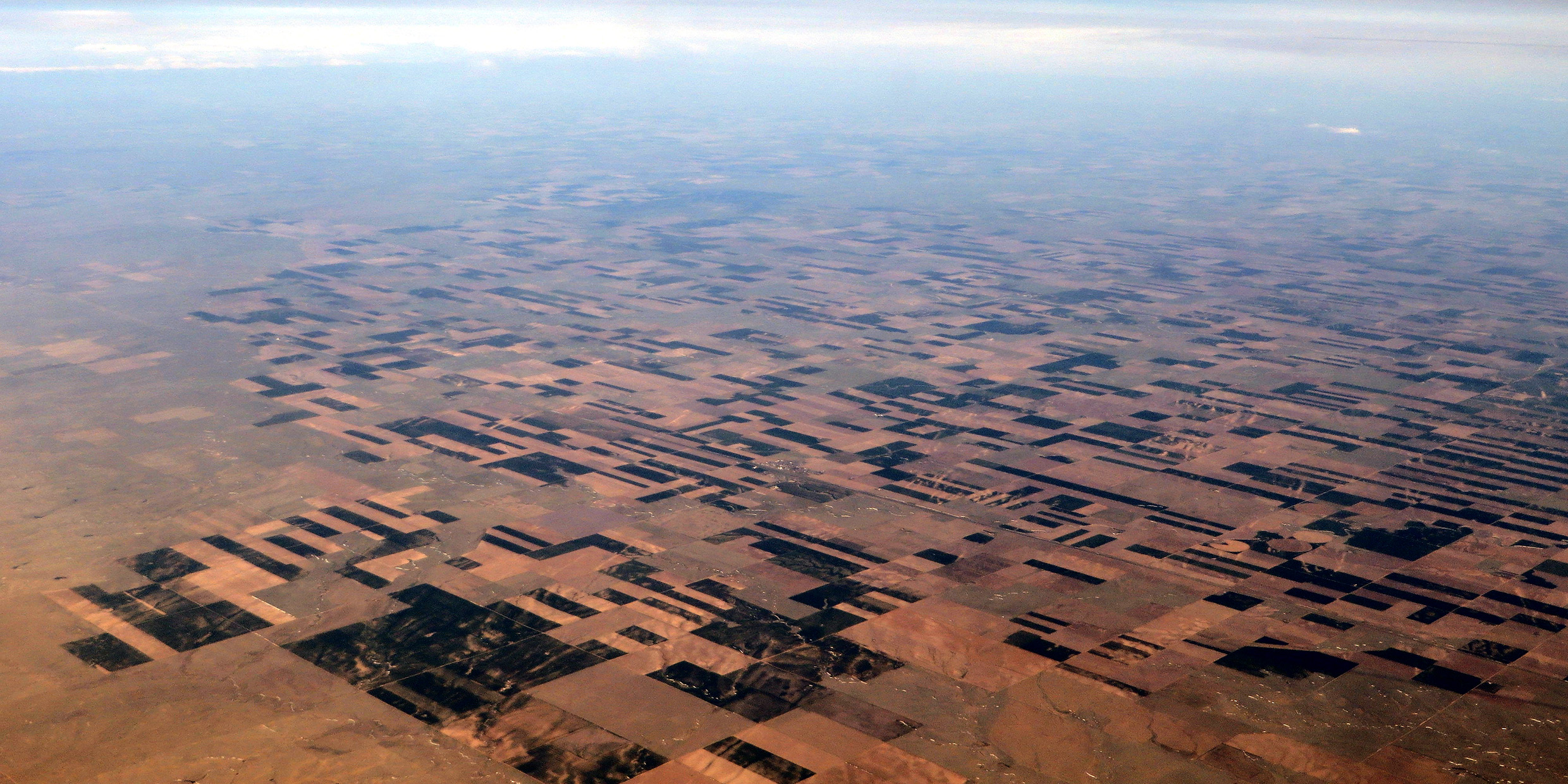
I was flying across the Northern Great Plains the other day at 37,000 feet. Not a cloud in the sky. The snow was melted in the fields but still banked along the roads. From the Appalachians to the Rockies, for a thousand miles, as far as the eye could see, the land was ruled by thin white lines (those snowy roads) into one-mile squares. The whole of the central United States was plotted out in a square grid as neat as the tiles on your kitchen floor.
But wait. I’ll come back to the checkerboard land. Let’s start in the sky. Let’s start with the constellations.
Patterns in the sky
For as long as humans have looked at the sky they have grouped the stars into patterns called constellations. Patterns that evoke familiar objects in the environment. Bears. Birds. Fish. Or inventions of the human imagination. Centaurs. Dragons. A flying horse.
Every culture makes pictures of the stars. Australian aborigines see kangaroos in the sky. Polynesians imagine fish. Eskimos fill the night sky with seals and polar bears.
Making pictures of the stars is a universal human trait, as natural as day and night. But only in western European culture have we found it necessary to put the pictures into square-cornered frames.
That’s right. The constellations on our western star maps are separated by straight-line boundaries. The boundaries follow north-south or east-west lines, and all of the lines meet at right angles. The American astronomer Benjamin Gould began this orthogonal mapping of the sky in 1875. The system was officially adopted by the International Astronomical Union in 1930.
Constellations are anachronisms for modern astronomers, but if we’re going to include them on our star maps then by golly we’ll lay ’em out with rectangular lines. It’s the western way, begun by Greek geographers and perfected by the philosopher-scientist René Descartes in the 17th century. Cartesian coordinates: that’s what we call his method of plotting the world on a graph-paper grid.
And not just the sky. Take a look at Manhattan.
From Wall Street in the south to Hell’s Gate in the north, from the East River to the Hudson, the city is a grid of rigid rectangles. The street plan ignores natural contours of the land, the curve of shorelines, watercourses, and patterns of drainage. The grid was laid out by a city commission in 1811. The commissioners had one objective: the efficient sale of land. Nature or esthetics didn’t enter into it. Right-angled houses are cheapest to build, the commissioners decreed, and right-angled houses fit best on right-angled lots.
The acknowledged goal of the 1811 commission was not to embellish Manhattan Island, but subdue it.
Something similar was at work in 1785 when the young Congress in Washington decreed that public lands west of the Appalachians would be surveyed and sold in squares. Six-mile squares called townships. Each township divided into 36 one-mile squares called sections (usually bordered by roads). Sections divided into four quarters. Bingo! The checkerboard grid I observed from 37,000 feet.
Patterns on the land
What I saw from the airplane is a classic example of western Cartesian efficiency. One million square miles of practical geometric utility. A geographic straight-jacket of mathematical lines. The rule of the square.
Our enthusiasm for the square has enabled us subdue nature with a dogged efficiency. The square-ruled earth and sky yield readily to scientific understanding and technological exploitation. We are richer, healthier, and more powerful than those cultures that are still bogged down in squiggles and curlicues.
The squaring of the circle is our secret of success.
But it’s a strange and unsettling sort of success. A success that has brought with it intractable environmental problems, a sense of disconnectedness from nature, and a kind of spiritual ennui.
This tension between nature and the square was easily observed from 37,000 feet, in the landscape below. Here and there, hills, watercourses, or a curving line of bluffs manage to frustrate the rectangular grid, forcing roads to deviate from their bee-line courses, nudging the boundaries of townships into gentle curves, or gracefully scalloping the square perimeters of farms.
It was like a map on top of a map. First, the map which is nature, a map of curvaceous surprises, concavities and convexities, oxbows and meanders. And, ruthlessly imposed upon the first, a second map, dead straight, T‑square perfect, square-cornered.
It was the best and the worst of western civilization.
What I saw from the airplane was the straight-edged cornucopia of our success: the efficient, ruthless, elegant, uncomfortable square.


